


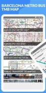


Barcelona Metro Bus - TMB map and route offline
Barcelona Metro Bus - TMB map and route offline ၏ ရွင္းလင္းခ်က္
Key features:
+All maps are offline. No internet connection required.
+High resolution map. Station name are clear and big enough to identify.
+Can zoom in, zoom out and scroll vertical and horizontal.
+Easy to use. Quick to find your place.
+Free of charge.
This app includes:
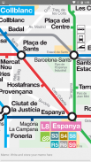
+ BARCELONA METRO MAP
+ BARCELONA BUS MAP
+ NEW BUS MAP NETWORK
+ PUBLIC TRANSPORT TO AIRPORT
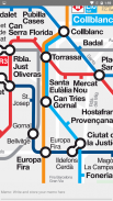
All the lines, stations, level of accessibility and links between lines in the metro, FGC railway, Rodalies de Catalunya main-line railway and TRAM.
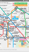
All bus lines and stops, and links to the metro, FGC railway, Rodalies de Catalunya main-line railway and TRAM.
အဓိကအင်္ဂါရပ်များ:
+ မြေပုံအားလုံးသည် offline ဖြစ်သည်။ အင်တာနက်ဆက်သွယ်မှုမလိုအပ်ပါ။
+ မြင့်မားသော resolution မြေပုံ။
+ ချဲ့ခြင်း၊ ချဲ့ခြင်းနှင့်ဒေါင်လိုက်နှင့်အလျားလိုက် scroll လုပ်နိုင်သည်
+ အသုံးပြုရန်လွယ်ကူသည်။ သင်၏နေရာကိုလျင်မြန်စွာရှာဖွေနိုင်သည်။
+ အခမဲ့ဖြစ်သည်။
ဒီအက်ပ်တွင်ပါဝင်သည် -
+ BARCELONA မက်ထရိုမြေပုံ
+ BARCELONA ဘတ်စ်ကားမြေပုံ
+ အသစ်ဘတ်စ်ကားမြေပုံကွန်ယက်ကို
+ လေယာဉ်ကွင်းသို့အများပြည်သူသယ်ယူပို့ဆောင်ရေး
ရထားလမ်း၊ ဘူတာ၊ ဆက်သွယ်နိုင်မှုအဆင့်နှင့်မက်ထရိုရှိလိုင်းများ၊ FGC ရထားလမ်း၊ Rodalies de Catalunya ရထားလမ်းနှင့် TRAM အကြားဆက်သွယ်မှုအားလုံး
အားလုံးဘတ်စ်ကားလိုင်းများနှင့်မှတ်တိုင်များ, နှင့်မက်ထရို, FGC ရထားလမ်း, Rodalies de Catalunya အဓိကရထားလမ်းနှင့် TRAM မှလင့်များ။
Barcelona Metro Bus - TMB map and route offline - ဗားရွင္း 1.2
(04-12-2020)Barcelona Metro Bus - TMB map and route offline - APK သတင္းအခ်က္အလက္
APK ဗားရွင္း: 1.2package: com.blogspot.metromapoffline.barcelonametrobustmbmapBarcelona Metro Bus - TMB map and route offline ၏ ေနာက္ဆုံးဗားရွင္း


က႑တူအက္ပ္မ်ား

သင္ႏွစ္သက္ႏိုင္သည္မ်ားမွာ...


